
Loop Staff Says Loop Will Cross Central
 December 11, 2011
  0 Comments
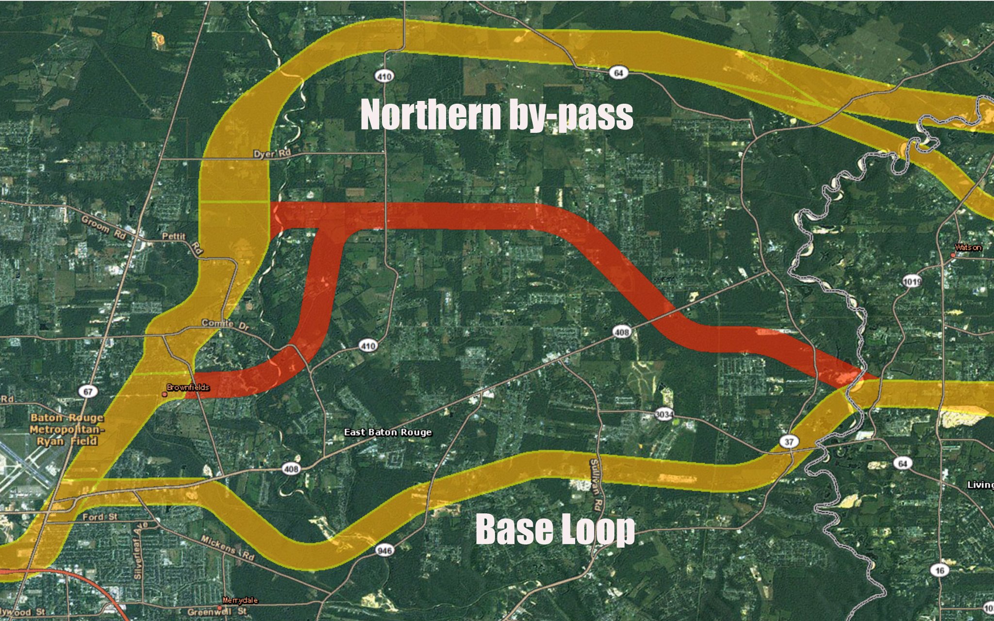
CENTRAL — Just last week, Central City Councilman Wayne Messina sponsored a resolution asking the Central City Council to take a position against the proposed Baton Rouge Loop. But when he walked into BREC headquarters on Florida Boulevard Monday night for the Loop’s Open House, no one seemed to recognize him. He wandered around to the different exhibits and stopped in front of a giant map of Central. The map was like that published in the Central City News last week, showing three possible routes across Central — the Northern By-Pass along Hwy. 64, a middle route along Denham Road, and the lower route that crosses Joor Road around Hampton Village and then heads east across Sullivan and Magnolia Bridge Road.
When a Loop staff member came by to visit with Councilman Messina, he asked which route the Loop would take through Central. The staffer turned out to be one of the Loop’s highest officials, program manager Suzanne McCain.
Messina asked Ms. McCain to explain the three routes across Central. “Well, the middle route has been eliminated. It won’t be considered any longer,” she said.
“What about this Northern By-Pass?” he asked. “That doesn’t work,” she said, “It’s really not a possibility. The route of the Loop is driven by tolls. This Northern route is too far north to attract enough traffic to pay the tolls to help pay for the project. This lower route [directly through the heart of Central] is the only one that is financially feasible,” she said.
Some Central residents have said they oppose the Loop but could live with the Northern By-Pass. However, Messina said, his meeting with the program manager of the Loop reaffirmed what he already knew — if the Loop is built, they plan to bring it right through the heart of Central.
“The traffic counts and the financial projections for the Loop don’t work,” Messina said. “If you move the Loop north of Central, their awful numbers get even worse.”
Last week, Central Economic Development Chairman Wade Giles told the City Council the Northern By-Pass is the most likely route, but this week Messina said there is nothing to back that up.
Also at last week’s Central City Council meeting, Central Chamber of Commerce chairman Tim Lazaroe urged the Council to try to have a representative of Central appointed to the Loop commission.
Messina said this is ironic. “Three parish presidents from Livingston, Ascension, and Iberville spent three years serving on the Loop commission,” he said. “They studied the proposed Loop and tried to work with it. But all three of them pulled their parishes out of the project, because they said it was flawed. So, at the same time that three large parishes are pulling out of the Loop, we are being urged to get in and become part of it and help keep it alive. That doesn’t make sense to me.”
How wide a strip through Central? In Saturday’s Advocate, Mayor-President Kip Holden said it would be 400 feet. But the Loop maps show a 1,500-foot “base corridor” through Central. See http://gis.ursbtr.com/interactivemap/.
In addition, the Baton Rouge Loop plan provides that these “corridors” would be preserved and could not be developed while the project is underway, if ever. In other words, private property in the 1,500 foot corridor would be tied up and could not be developed for years while rights of way are being acquired. The idea is to tie up people’s land, without paying compensation, until the Loop decides whether to acquire it and what developers to allow to build shopping centers and residential areas in accordance with the Loop’s development plans.
The Loop plan says, “it is likely that the Loop will be developed in phases; so the right-of-way acquisition will continue for several years. For these two reasons, it is important to develop and adopt a corridor preservation approach for the project. A corridor preservation plan will facilitate the project development in several ways: 1) it will be a means to ensure that current undeveloped portions of the route(s) that have been selected for the Loop will have the best chance to remain undeveloped; 2) for current developed properties which may be affected by the Loop, it will provide information and processes that allow for orderly planning and adjustments… See Executive Summary- Traffic, Revenue, and Phasing at http://brloop.com/docs/ExecSummaryImpPlan_Final.pdf.
Would Loop through Central require the construction of high walls for noise abatement? In the Saturday Advocate, Mayor-President Kip Holden said it won’t. However, the Loop would create a tremendous amount of noise, and Federal law requires noise abatement, normally in the form of high walls, up to 25 feet. The Loop’s “base” route from Joor Road to Sullivan Road to Greenwell Springs Road passes close to many residential areas.
For reference, here is a listing of the noise level created by various sounds:
10 a light whisper
20 quiet conversation
30 normal conversation
40 light traffic
50 typewriter, loud conversation
60 noisy office
70 normal traffic, quiet train *****
80 rock music, subway
90 heavy traffic, thunder *****
100 jet plane at takeoff
Here are the facts from the Federal Highway Administration:
1. For all NEW projects (Type I), a noise abatement analysis is mandatory.
2) “The construction of a noise barrier is the mitigation measure most often associated with the concept of noise abatement.”
3) “[Walls] are usually limited to eight meters (25 feet) in height because of structural and aesthetic reasons.”
4) Here are the noise abatement standards:
Table 9
Noise Abatement Criteria (NAC)
Hourly A-Weighted Sound Level – decibels (dBA)*
Activity
Category Leq(h) L10(h) Description of Activity Category
A 57 (Exterior) 60 (Exterior) Lands on which serenity and quiet are of extraordinary significance and serve an important public need and where the preservation of those qualities is essential if the area is to continue to serve its intended purpose.
B 67 (Exterior) 70 (Exterior) Picnic areas, recreation areas, playgrounds, active sports areas, parks, residences, motels, hotels, schools, churches, libraries, and hospitals.
C 72 (Exterior) 75 Developed lands, properties, or activities not included in Categories A or B above.
D — — Undeveloped lands.
E 52 (Interior) 55 (Interior) Residences, motels, hotels, public meeting rooms, schools, churches, libraries, hospitals, and auditoriums.
Source: http://www.fhwa.dot.gov/environment/noise/regulations_and_guidance/probresp.cfm#abatement


Comments are closed.